HOME | ISUUE COVER

Science, People & Politics, ISSN: 1751-598x. Volume iii, Volume II, 10th January, 2011.

In the depths of the volcano

by Martin Redfern

As European air travellers learned to their cost in April 2010, Iceland is a volcanic island. On the fourteenth of that month Eyjafjallajökull erupted, sending hazardous clouds into the atmosphere. What had begun a month earlier as a local geological event had gone international.

Between 15th and 21st April 95 000 flights were cancelled lest the volcanic dust melt on the high temperature turbine blades and clog their cooling pores. Most of north western European airspace was closed, at a cost to airlines alone of, minimally, $1.7 billion. Though that eruption has now subsided it is only a matter of time before another happens. When will that be and how serious?

Last August I joined a small team of volcanologists in Iceland who are trying to find out.

Our expedition was led by Professor Hazel Rymer from Britain's Open University. She has visited the island for 25 years, monitoring tiny changes in gravity that might signify fresh magma rising under Askja, one of the largest volcanoes in north east Iceland.

To reach the site involved several hours of off-road driving. Where the track ran across plains of volcanic ash it was relatively smooth and well marked. A luxury which faded once the winding route ascended into the jumble of solidified lava flows where little distinguished it from the surroundings, and it would have been easy to end up driving over a precipice. For that reason the main track mostly follows close to the river draining the great Vatnajökull ice cap.

But the river, swollen with summer melt water and persistent rain, chooses its own path independently of the road. By the time we reached them the occasional wooden stakes marking the track had disappeared into turbulent waters, forcing an even longer detour. Not only the weather had swollen the river: dark ash from Eyjafjallajökull's eruption earlier in the year covered much of Askja's ice cap and absorbed heat from the sun, increasing the melting of the otherwise white, reflective ice below.

Eventually we reached the 8-kilometre central caldera of Askja. A barren landscape greeted us: grey, jagged lava flows, grey mounds of ash and grey clouds spitting driving rain. No colour in the immediate forground except a distant smudge of yellow where escaping gas had deposited sulphur. It seemed a lunar landscape and, indeed, this is where NASA brought the Apollo astronauts for training in field geology.

Undeterred Professor Rymer and a colleague from the University of Chile strode confidently over the treacherous rocks to a small brass pin that marked one of the points where she has measured gravity for a quarter of a century. I was introduced to G 513, the trusty instrument Hazel has used throughout that period to ensure consistent measurements. Its sister gravity meter was destroyed by an eruption in Colombia in 1993, when nine geologists died.

Professor Hazel Rymer and Andres Pavez take gravity readings in the Askja caldera. Photograph copyright, Martin Redfern.*

Professor Hazel Rymer and Andres Pavez from the University of Chile take gravity readings in the Askja caldera in Iceland.


Photographer Martin Redfern©. These photographs were taken during an expedition in August 2010. Photpgraph edited and detail blurred at the time of publication by Helen Gavaghan. Copyright attributions clarified 13th February, 2017. HG.

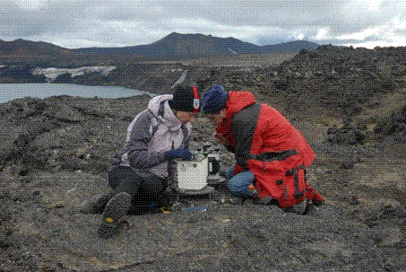
The instrument can measure the pull of gravity with such precision that a vertical movement of just a centimetre, or the state of the tides, requires corrections. Over the years the measurements reveal the breathing of the volcano as molten magma rises and falls deep beneath the surface.

Iceland isn't really land at all but rather a section of the mid-Atlantic ocean ridge that happens to be higher than the rest and which rises above the waves due to an up welling plume of hot material from the Earth's mantle. Iceland is only here because of volcanoes, and because volcanoes are constantly replenishing and extending the island. But exactly when and how a particular volcano will erupt is very hard to predict.

Askja is the biggest volcano in Iceland's north eastern volcanic region. Its last eruption, in 1961, was relatively mild, producing the long black flows of basalt that we struggled to cross. They make a jagged, fractured mass, revealing close up the flow marks you might expect from squeezing out a giant tube of viscous black toothpaste.

In 1875 things were very different. Then, rising fresh magma broke into the existing magma chamber about five kilometres beneath the volcano and "fizzed it up", releasing a huge volume of gas - like dropping sugar cubes into cola. The resulting explosion blasted out a crater 4-kilometres across, filled now by the deepest lake in Iceland. The huge quantities of light, frothy pumice or tephra it spewed into the air cloaked the surrounding landscape. The finer particles reached Europe and would certainly have disrupted flights had there been jet engines at the time. The eruption occurred in the winter, and Hazel showed me a thick layer of 1875 snow trapped beneath the insulating lava and pumice. We trod with care because the ground caves in where it melts.

So what will happen next? Preliminary analysis of the 2010 measurements suggests that a brief rise in gravity in the caldera has subsided again, but for how long? Another team we encountered, from Cambridge University, struggling with a leaking fuel can in their Land Rover trailer, has detected micro earthquakes 20 kilometres beneath the volcano, perhaps signifying magma on the move. And Askja is just one of dozens of active volcanoes in Iceland. Some, like Eyjafjallajökull and its larger but more pronounceable neighbour, Katla, lie beneath ice, posing the risk of potentially explosive eruptions as the magma reacts with melt water. Others, like Askja in 1875, can explode without external help. Further ash clouds are inevitable. The only question is when - and in which direction the wind will be blowing at the time.


Martin Redfern is a senior radio producer with the BBC World Service. He submitted this story to Science, People & Politics on 9.11.10 and it was accepted by the magazine. Copy editor: Helen Gavaghan. Editor's suggested further reading: Geodynamics, second edition, by Donald Turcotte and Gerald Schubert. Cambridge University Press 2002. I bought this book in 2003 when working on a transfer report from M.Phil. to Ph.D at The Centre for the History of Science Technology and Medicine at the University of Manchester, where I was undertaking post graduate historical research into the International Geophysical Year of 1957-1958. Martin has a degree in geology from University College, London. HG.

TOP

GavaghanCommunications Science, People & Politics©. All rights reserved.

|